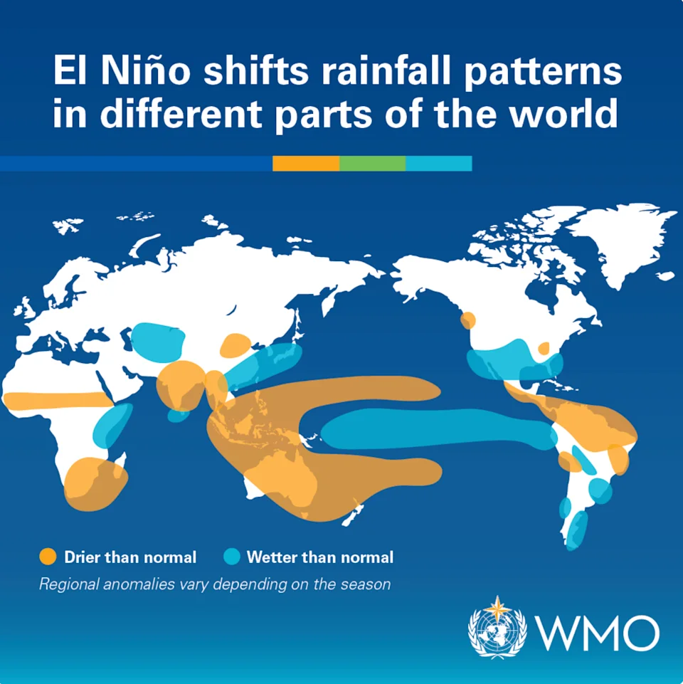
Scientists have warned that this year’s El Niño could become one of the strongest — if not the strongest — on record.
Analysis released by Berkeley Earth, a nonprofit climate research group, on July 23 found a 90% chance that El Niño will push tropical Pacific temperatures beyond anything recorded in about 150 years of observations. That would increase the likelihood of higher global temperatures and more extreme weather.
El Niño — which officially formed in June — is a natural climate pattern that can bring extreme weather to many parts of the world, including the U.S.
It can dramatically reshape weather across North America, increasing the likelihood of wetter conditions in the South, milder temperatures in the North and a quieter Atlantic hurricane season.
The World Meteorological Organization expects El Niño to persist well into late 2026, and its most significant effects on U.S. weather are likely to emerge in the fall and peak during the winter.
What will this mean for the weather in the U.S.?
The severity of El Niño’s impacts depends on where you live.
“El Niño tends to increase the storm track over the southern tier of the United States, increasing the chances of above-average precipitation,” Michelle L’Heureux, a physical scientist at NOAA’s Climate Prediction Center, told Yahoo News.
Northern parts of the country could see warmer temperatures, while other regions may experience drier conditions.
She said the southward shift in the storm track also leaves parts of the northern U.S. drier than normal and increases the likelihood of above-average temperatures.
How will El Niño impact where you live?
Each El Niño event is unique in terms of its evolution, spatial pattern and impacts.
(World Meteorlogical Organization)The South and the Gulf Coast
A strong El Niño typically brings wetter and cooler-than-normal conditions from late fall through winter. Thunderstorm activity often increases along the Gulf Coast and in the lower Mississippi and Tennessee valleys. Spring and summer wildfire risk also tends to decrease across the Southeast.
California and the Southwest
El Niño often brings wetter-than-normal conditions, especially during midwinter, although the signal is less consistent than in the Southeast. Increased precipitation can also reduce spring and summer wildfire risk across parts of the Southwest, including the Great Basin and southern Rockies.
The Pacific Northwest and Northern Rockies
A strong or very strong El Niño typically brings milder conditions and below-normal snowfall as Pacific air limits the buildup of cold air over western and central Canada. Parts of the Rockies can receive above-normal snowfall, while the northern U.S. tends to be warmer and drier, increasing spring wildfire risk in the Northern Rockies.
Tennessee and Ohio Valleys
Winters are often drier than average, particularly across the Ohio and Tennessee valleys. At the same time, El Niño can increase thunderstorm activity from the lower Mississippi Valley into the Tennessee Valley.
The Northeast
A strong El Niño generally brings a milder winter with below-normal snowfall across much of the region. Despite the warmer pattern, the risk of powerful coastal storms, including nor’easters, can still be elevated.
What will it mean for storms?
A strong or very strong El Niño typically strengthens the subtropical jet stream during the fall and winter, steering more storms across the southern U.S. and suppressing Atlantic hurricane activity, according to Steven DiMartino, chair of the American Meteorological Society’s Board of Digital Meteorologists.
“While you only need one hurricane to have significant impacts, a very strong El Niño produces significant wind shear in the tropical Atlantic,” he said. “That prevents most tropical waves from forming and threatening the U.S.”
“The biggest impacts from El Niño tend to occur in the winter months, though the effects may linger beyond the winter,” Nat Johnson, a physical scientist at NOAA’s Climate Prediction Center and lead of the El Niño Southern Oscillation team, told Yahoo News.
Johnson added that during the following spring and summer, El Niño can increase or reduce the wildfire risk depending on where you live.
How strong will this El Niño be?
Forecast models increasingly point to a powerful event, as a large reservoir of heat remains beneath the tropical Pacific and the atmosphere is now reinforcing the ocean warming rather than suppressing it.
Berkeley Earth analyzed 14 forecast models to make its predictions, which project that sea surface temperatures in the El Niño region — central and eastern equatorial Pacific Ocean — will peak at around 3.6°C above average, potentially surpassing the previous record of 2.75°C.
“The current trends and developments support that this El Niño will surpass the 1997-98 and 2015-16 events, which are considered the strongest on record,” DiMartino told Yahoo News. “Given that El Niño’s peak is in late November, the potential to rise as much as +3.0°C or +4.0°C is becoming increasingly likely.”
NOAA is also forecasting a major El Niño, giving it an 81% chance of reaching “very strong” status. However, the agency has stopped short of predicting it will become the strongest on record.
“NOAA is not saying there is a 90% chance of becoming the strongest in 150 years,” L’Heureux said. “In our monthly discussion update, we also wrote that we are referring to our historical record going back to 1950. We do not have enough confidence in the record prior to 1950 to be making comparisons before then.”